Friday 10 October 2014

The Mystery of Broadclough Dykes

Was Bacup a Viking Stronghold?


The enigmatic Battle of Brunanburh, (937 AD) fought between Athelstan's rampaging Saxons and the leader of the Irish Vikings, Olaf - was one of, if not the biggest battle ever fought on British soil.  The Vikings, we know, had 615 ships amounting to as many as 30,000 men!  Clearly, the battle must have been like two opposing football stadiums attacking each other.  What we do know is that the Vikings ralled support from the Scots and Strathclyde Britons, making a massive coalition - and that they landed and that they sailed up a river before doing battle.  What we don't know, with any certainty - is if this landing took place on the east or west coasts.  Surely from Ireland a west coast approach would be logical, but in rallying the Scots, did Olaf cut through Northern Scotland and assemble his forces on the North Sea?  We will never know - and one of the most infuriating puzzles of British history concerns the location of the battlefield itself.  A mass slaugher with thousands of men involved, lasting a full day - but noboby knows where it took place.  In the 19th century, this hillside in Bacup. Lancashire, was firmly linked with the battle, the River Brun lying in nearby Burnley.  The massive earthworks here, above the hamlet of Broadclough - has been a source of fascination for centuries.


We are talking about manpower on a grand scale here.  A mile out of Bacup on the road to Burnley - a track on the left leads up to this gigantic entrenchment - 6oo yards long (1800 feet) with a trench at least 54 deep at the bottom.  This aerial photograph shows it superbly.  The industrial revolution takes such pride of place in Lancashire history that the ancient relics often get overlooked.  I'm pretty sure that, was this site south of Birmingham, it would have been fully excavated and explored.


The Broadclough Dykes were first written about in detail in Thomas Newbigging's classic: 'History of the Forest of Rossendale.'  (1868)  


Newbigging's book has pride of place in my bookcase.  I was brought up with it in a way - and its frontispiece never fails to impress - showing the first woollen mill ever built in this industrial valley: Hareholme Mill - with a facing engraving of Wolfenden Booth - an ancient part of the forest.


This is the chapter where Mr Newbigging, who lived at the old coaching house off Todmorden Road in Bacup - shows his appreciation of the Dykes, and proposes them as  a site for Brunanburh. 


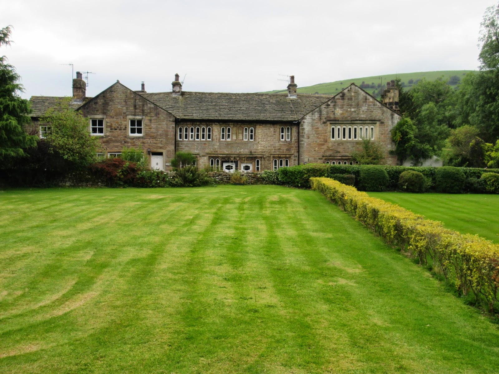
Dykes House Farm - off Burnley Road at Broadclough, Bacup - was derelict for many years.  I heard rumours that nearby mine workings had caused the entire foundations to slip - with a massive crack appearing down the building.  Now it has been lovingly restored - and what a place to live.


On the way up the the farm and the Dykes, we pass the remains of the old Broadclough colliery - which was re-opened as a drift mine by the National Coal Board in the 1950s and closed in the late 60s.  This is the weighing house - now used for farm storage.


This is where I live - and I feel quite lucky.  The hamlet of Broadclough is in the trees - and here we see the weighing house as we look east over Old Meadows, site of another major coal seam.


On the right as we head up to the Dykes, the beautiful weavers' cottages of Step Row mark the position where the ancient road to Burnley used to turn at 90 degrees through a farm yard at the old Roe Buck Inn - and ascend steeply up onto the moor.


From a higher position - Step Row is beautiful indeed - as is the view over Old Meadows to the east.  It's a wonderful part of Lancashire.


Dykes House Farm, looking over Old Meadows.  The ponds on the right were constructed in the 1990s to filter iron oxide - locally known as 'carr water' from the River Irwell - which had been stained orange by the mining operations nearby.  We will visit the Old Meadows area later.  Fish haven't yet crept back into the upper reaches of the Irwell - bu the water is now crystal clear.


This is one of my favourite situations in Lancashire.  I am stood on the massive rampart of Broadclough Dykes, looking over Dykes House Farm to Old Meadows - with Hogshead Law Hill on the right.


Behind the farm - a line of trees marks the entrance to this fabulous place.  Even from here - the scale of the entrenchment is really impressive.  Just think of the number of men who must have been at work here - with nothing more than basic shovels.  The mind boggles!


Looking at Broadclough Dykes from the morth entrance.  The sloping banking to the left is actually a continuation of the hillside on the right - so the soil has not been dug out and used to make the rampart - as the shale beds are still all in place.  Thomas Newbigging suggests the enormous amount of soil, shale and clay was actually transported out of the trench as it was dug and scattered over the fields near to the main road.  The loose nature of the soil in these fields (it's impossible to dig a hole without soil caving in) suggests he might well be right.  Imagine thousands of men here toiling in wild conditions ....


Looking back out of the northern entrance - with the full width of the trench seen.  If the Vikings did land on the west - as Newbigging suggests - they will have been expecting a Saxon approach from the east or south.  The area was probably much more extensively wooded so lookouts on the hills above the Dykes wil lhave kept watch to the west - where it is possible to see for miles towards Blackburn  - while the east has limited views in terms of distance .....


If Olaf the Viking did travel through Scotland to the North Sea and sail up the Humber - we have a very different possibility.  Could this be a Saxon defence, built to keep watch for approaching Vikings from the east? Yet the structure of it fits with Danish defences - and it's a great puzzle.  Here you can see the depth of the excavation by looking at the height of the banking on the right.  Silt and leaf-fall - as well as erosion of the banking - will have greatly reduced the depth over the centuries.


Looking south-east across the trench to the rampart, and over the town of Bacup.  Any approaching army would first be seen three miles away.  In the 1970s, the Bacup Natural History Society carried out a few small digs, but found nothing conclusive.  The Dykes clearly need putting to bed with a full scale investigation such as Leslie Alcock carried out at Cadbury Castle.


The pathway oout of the Dykes to the west.  Is it possible this was the main entrance for the workforce - who must have been toiling for months on this earthwork?


A soldier's eye view to the east - looking into the trench.  A wooden stockade may well have spanned the rampart making it impregnable from the east - but a charging army would have has a dwonhill advantage from the positio of the camera.  Therefore it is highly likely that the hillside above the Dykes (behind the camera) was thickly wooded and overgrown - with its own natural defences.


Looking north across the entire width of the trench and showing a good view of the rampart on the right.


Looking south showing the full width of the trench.  The rampart is less pronounced in the southern section.


The rampart of Broadclough Dykes is remarkably well preserved, and the greatest threat to it is actually the constant digging by rabbits.


Looking at the hillside on the left and the rampart on the right - you can get some idea of the vast undertaking required to make this defence.  Clearly, something dramatic was expected around what is now Bacup - all those years ago.  Even modern diggers would take days to excavate such a huge ditch.


This area to the south of the Dykes has always puzzled me.  All of a sudden the trench stops - to be replaced by the natural slope - then carries on towards Setting Barn Farm, with the rampart once again clearly seen in the trees.  The ground on the slope is, however, disturbed and uneven.  Was this where the soil was accumulated before being transported by cart down the hill?  Was it heaped up here, just off centre - as men were digging from each end?  If so, why was it not continued afterwards?    Could this area have been a settlement - with the Dykes either side - where those who supervised the proceedings actually lived - surrounded presumably by a stockade?  Or was the Dyke simply abandoned and never used?  Did the Viking army - if indeed it was them - receive news that the Saxons had shifted their position?  Will we ever know?


This is where the Dykes temporarily end - at the south side - looking north along the rampart back to Dykes House Farm.


The Dykes from above.  Yes - it would be easy to charge down this hillside and massacre those in the trench, but not if these slopes were thick with vegetation a thousand years ago,


There are signs of history everywhere in the Irwell Valley - just north of Bacup town centre.  Here, this stone pier on the bank of the Irwell used to support an iron trellis bridge that spanned the road and allowed tubs of coal from two collieries - either side of the road - to be brought into the coal staithe.


The Old meadows Colliery was situated here - on the east side of Burnley Road (opposite the Dykes). The remains of the lamp room have now been converted into a dwelling - while this track marks the position of the old chain haulage system.


Looking down the line of the old chain haulage system.


The exact position in the 1960s, not long before Old Meadows closed.  Note the fencing made from old lengths of chain.  It was tough work in this pit - and conditions tested even the hardest miners.


Looking across from Old Meadows to Broadclough Dykes.


Three periods of Bacup history:  in the foreground, the lamp room of Old Meadows Colliery - now a house - with the chimney of Broadclough woollen mill (originally 18th century) in the background. The Dykes dominate the landscape as a major slice of ancient history.


The superb stone arch spanning the old bridleway near Old Meadows Colliery.  Its exact function is unknown.


A wonderful Broadclough panorama: with Whittaker Clough on the right - the remains of Broadclough Colliery at centre and the Dykes, as ever, dominating the hillside.


Heading up the old road to Deerplay on a section known as the 'Kirk Gate' - which led over to Newchurch via the moors.    This was formerly the main highway to Burnley from Bacup.


Just off the old Deerplay Road is this interesting earthwork - a feature that has never been fully investigated and which lies more or less on the same contour as the Broadclough Dykes - about half a mile to the north.


Again it's a huge and no doubt very ancient feature - and common sense would seem to point at it being contempoary with the Dykes.  Was the original plan to fortify the whole of this side of the valley?


Walking the perimeter of the feature showing the massive banking on the left.


Looking up at the very obvious earthwork.


At the north-east corner of the earthwork is this obvious raised causeway with a ditch to the west.


Another intriguing view into the earthwork off the Deerplay Old Road.


More or less a replica of the Dykes - on a slightly smaller scale.


The Irwell valley north of Bacup repays the intrepid explorer with dazzling views, great history - and a sense of loneliness that you won't find in the nearby national parks.  Go and see it for yourself.

Tuesday 16 September 2014

The Lancashire Witches, 1612

A photographic guide to the haunts of Old Demdike


Pendle Hill towers over Lancashire like a colossus; its 1831 feet appearing double the height from certain angles - and its slopes often clothed in cold mist.  Nobody can look at this enigmatic hill without a shudder, for beneath its slopes, during the reign of King James I, events took place leading to the most famous and notorious witch trials in English history.  Elizabeth Southern, an 87 year old grandmother, already known as a 'cunning' woman with her ability to use magic on sick animals - was known to all as Old Demdike, and was the absolute ruler of the roost.  Her daugher, also Elizabeth and married to John Device, was born illegitimate and had the misfortune of having one eye pointing upwards and one down - popularly referred to as 'Squinting Lizzie.'  She herself had three children: James, 11 year old Jennet, who was to betray her entire family in court - and the redoubtable Alizon .... and it is with Alizon, the 'middle child' - that our story begins ....


Alizon, like all members of the Demdike brood, made her living by begging.  One day in March, 1612, she was walking to Trawden in search of rich pickings - and passed through the old market town of Colne onto this road.  Coming the other way was John Lawe, a pedlar, and Alizon - as was her custom, asked him if he had any copper pins in his backpack.  These pins were used for pinning cloth but were useful for all kinds of witchcraft.  Law could not be bothered opening his bag for such a trivial item ... and what happened next would go down in history and start the ball rolling which led to the brutal round up of the so called 'witches of Pendle.'


Alizon had with her a black dog, her 'familiar' - and as the pedlar moved on, following much arguing, Alizon later testified that the familiar said, 'what woudst thou have me do with yonder man?' to which Alizon said, 'What canst thou do?' and the dog replied 'I can lame him.'  Alizon told him to go ahead, and within a few yards Lawe collapsed onto the road, a stroke having been brought on by the pressure of his argument with the girl.  Alizon, startled at her own powers, seems to have been genuinely devastated that this 'witchcraft' had such horrific results.  As Lawe was taken to a nearby inn, she visited his bedside and confessed her guilt to Lawe's father, dropping to her knees and begging forgiveness.  It was, she said, her Grandmother's fault.  Old Demdike, of Malkin Tower, had taught her to be a witch from a young age, and thought nothing of making clay images of people she had a score to settle with, and sticking pins where she wanted the person to receive pain or illness.  Ah, yes - blame Grandma ....


Horrified, Lawe's father reported this to a local magistrate, Roger Nowell, who knew that rounding up witches (King James's pet hate) was likely to lead him to promotion.  Nowell acted fast, and Demdike, Elizabeth and Alizon - together with Old Chattox, leader of another family of witches from the west of the district, were interrogated and sent to Lancaster Castle .... just the beginning of the story. 


Demdike's home was 'Malkin Tower', mentioned countless times in the account of Thomas Potts, the clerk to the court at Lancaster, and its location has been debated for centuries.  It was likely to have been a hovel - a small thatched cottage or even a converted hen house - and for years it was believed to lie here, on the site of Malkin Tower Farm in Blacko. 'Malkin' here comes from 'Mawkinhole' - a depression behind the farm. The name is identical - but this site lies three miles from the centre of the main witch activity and Blacko doesn't get a mention in any of the accounts.  It is unlikely that an 87 year old woman, partly blind, could have walked from here to Newchurch-in-Pendle on a regular basis.  And before you suggest it - no she didn't fly on a broomstick!


Behind the current Malkin Tower Farm is a grassed-over ruin, and this was until recently believed to have been the home of the Demdikes.  Recent archaeological work has produced no evidence ...


The grassed over mound was thought to have been a cottage - but investigations have shown it to be more recent than early 17th century.    Malkin Tower's whereabouts is fascinating for several reasons: not least because, on Good Friday of 1612, a few weeks after Demdikes's imprisonment, a great gathering of 'witches' took place at the site; James Device providing a stolen sheep to feed the guests, who were many and varied.  While the community were worshipping at Newchurch, the coven at Malkin Tower had something more sinister on their minds: how to rescue Demdike and her clan by blowing up Lancaster Castle and murdering the gaoler!  At least, this is what 11 year old Jennet Device told the court.  In reality, she is likely to have got the wrong end of the stick when one of the guests may have shouted out in fury: 'I'll blow up that bloody castle!' or 'I'll bloody murder that gaoler!'  In any case, she condemned her family to the gallows ...


One of the great enigmas of the Pendle witch story is the fate of Alice Nutter.  Alice, a relatively wealthy catholic of Roughlee, was not the sort to be associated with the 'low life' of the Demdikes: yet on Good Friday 1612 she was there, at the Malkin Tower meeting, sampling the mutton and presumably sympathising with the plotters.  This superb sculpture of Alice Nutter stands in Roughlee. Why she ever met with a group of witches remains a great mystery.


Alice was given away by 11 year old Jennet Device - the court's star witness - who picked her out of an identity parade at Lancaster Castle when she was asked to  confirm all those who she said had been present at the meeting.


The legend is that Alice Nutter lived here, at the stunning Roughlee old hall - but in fact recent research has shown she lived at Crowtrees, a farmstead half a mile to the west. Throughout her trial, Alice Nutter remained silent and did not seek to defend herself.


So where, then, was the notorious 'Malkin Tower'. Early accounts suggested here, at Saddler's Farm in Newchurch - now, ironically, a Christian centre.  There was mention of the surrounding fields being called 'Malkin Fields' - but there is no mention of this on historical deeds ....


The stereotype of Demdike's lair would be a cottage under the brooding slopes of Pendle itself, and this is indeed where modern historians now place the site of that Good Friday meeting.  This is Mancknowles Ing, in Barley - an 18th century cottage built on an enclosure containing several industrial ruins.  'Ing' refers to the meadow, and this was the land of John Mancknowles in the late 16th centurry.  Mancknowles Ing would have been shortened from its three syllables to 'Manking' - and the 'Tower' could well have been an isolated grain kiln as it is known from examining the nearby stream culvert that grain was processed in this area.  One of the daughters of Old Chattox, Bessie Whittle, also mentions going into the 'firehouse' at Malkin Tower - which may well have been the old grain kiln converted into a dwelling.  Say 'Mankin Tower' as they do in Pendle - and 'Malkin' easily becomes the sound picked up by the ear.    This site is also close to the centre of recorded witch activity.


I have visited, many times, the three contenders for Malkin Tower, and I have no doubts personally that this is the one.  The presence of something unusual is so clearly felt here.  It is an amazingly amospheric spot.


The more recent building, it has been suggested, may even contain timbers from an earlier dwelling. To the left of the image the raised ridge culminates in a mound next to the farm, containing the tantalising remains of a building.


Here indeed is the mound - and was this the very spot where the mutton was roasted, the plots concocted, and - ultimately, the arrests made?  Historians think they are closer to Malkin Tower with this spot than they have ever been - and the thought of a full scale dig is exciting indeed.


Looking a the mound from this side, the remains of a building can clearly be seen.  It would have been simple for Demdike and her clan to walk from here to Newchurch on their begging missions.


Mancknowles Ing - 'Malkin Tower' from the west - the raised mound being to the right of the photograph.


Even though the building is of a later date than 1612, you couldn't imagine a better setting for a coven if you tried. Fascinating!


The setting for Malkin Tower - in the heart of the ancient Pendle Forest.


The view of Pendle Hill from Malkin Tower - as it would have been to the Demdike brood.


Lancashire witch country is rustic, atmospheric and very English.  


Just west of Newchurch-in-Pendle is Faugh's quarry.  This is the 'stonepit' where, twenty years before her trial, Demdike told the magistrates she had met a boy dressed half in brown, half in black, who said she could have anything she wanted if she gave him her soul.


This was the day, Demdike said, that she became a witch - and Tibb didn't return to her for some years - when he came in the form of a brown dog and sucked her beneath her arm, driving her mad for days afterwards.


Demdike's stomping ground was this corridor of land between Sabden and Newchurch, known in 1612 as Goldshaw Booth.  Here she would invariably be given milk or oatmeal and be told to get on her way - but farmers sometimes asked her to use her magical powers on their sick animals - with a kind of grudging respect.  Anne Whittle, Old Chattox, was the head of the other main witch family and lived in West Close, in the distance to the right of the photograph.  The two women, by all accounts, hated each other.


John Nutter, of Bullhole Farm, asked Demdike to cure his sick cow, but she had a score to settle with him, and bewitched the animal to death instead.  Nice!  Chattox on one occasion managed to scrounge a dish of 'blue milk' from this farm and immediately set about churning it with a stick into butter while reciting a string of words over it.  Presumably, butter was easier to carry back to her home at West Close than a dish of milk.  Nutter was having none of it, and promptly kicked over the dish of milk, only to be verbally cursed by an infuriated Chattox.  Next day, to his horror - one of his cows died.  Even today Bullhole Farm, one of the few remaining 'definite' Pendle Witch sites, has horse-shoes above the doors and windows to keep witches at bay.


This is actually one of the biggest areas of witch activity in Pendle. Many of the classic accusations concerned activity in these fields. When 'Squinting Lizzie's' husband, John Device, just once failed to pay 'oatmeal' duty to Chattox, based on an agreement they had made years before - she 'murdered' him by witchcraft. This caused massive friction between the Chattoxes and the Demdikes - and James Device was only too happy to see Chattox condemned, not realising he was sealing his own fate in doing so. At her interrogation, Chattox competed with Demdike, refusing to let the 'wizened hag' appear superior on any level. Demdike escaped the hangman by dying in the stench and filth of the dungeon before the main trials began.


The begging ground of Demdike and Chattox.  This, one of the most haunted areas in Britain, is added to by the reputation of Tynedale Farm, seen flanked by trees near the skyline right of centre in the upper part of the photograph.  Here, sightings of a phantom monk kneeliing to pray by the roadside are commonplace, as is the presence of a female servant in a long gown. A camera crew, filming 'Most Haunted' experienced breathing difficulties when trying to record film inside the barn.


Old Chattox herself, Anne Whittle, lived in an area known as West Close, near Higham, and we have one tantalising clue as to the location of the witch's dwelling ....


When questioned by Roger Nowell, Old Demdike was only too willing to drop her great rival in the mire.  One day, she recounted, she had been returning from a begging outing when the track happened to take her past Chattox's house.  There she saw Chattox in the garden, busily making clay images (presumably of Robert Nutter who had upset her daughter).  So shocked was Demdike, and so engrossed, that she 'fell in a ditch' at the foot of the garden in her bid to get away from Chattox's invitation to join in.  An ironic statement from the most notorious witch of them all! Demdike and Chattox probably once got on well: only in later life did their families grow to hate each other.


Of all the farms in the West Close area - only this one, known as 'Heys' matched Demdike's description, and exactly, for the ditch lies on the route of an old track past the farm.  Is this, then, the very spot where Demdike turned and saw her great rival at work?  The ditch is certainly very pronounced - but the building itself is later than 1612 - research showing it is built on the spot of an earlier dwelling.  There is a very good chance, according to historical research, that Old Chattox lived in this exact spot.


Looking along the 'Demdike Ditch' next to the Heys Farm.


The location of the home of Old Chattox, from the south.


 Newchurch-in-Pendle is the most famous village in the area.  The 16th century tower is the only part of St. Mary's Church that would have been known by the witches.  Beneath the clock, the all-seeing 'eye of God' keeps watch for evil spirits in the churchyard, and with good reason.


The church is quaint - with a fascinating variety of tombstones - and one or two in particular that have attracted visitors for centuries.


This table-like tombstone is often called the 'Witch's Grave' from the skull marking on the stone, and it is flanked by a grave of the Nutter family - dating to 1651.


All these were relatives of Alice herself, and it is tempting to think that her family may have buried her remains here in secret following her hanging.  Certainly, no convicted witch would ever be allowed a place on consecrated ground.


The skull, the symbol of death, was in fact quite a common marking on 17th century tombstones - but there are still many who believe that Alice Nutter's remains lie here in the family plot.


James Device, given away by his sister Jennet to be a well practised witch himself, confessed to seeing Old Chattox digging up graves in the churchyard for teeth - some of which she used herself, and some of which, in a kind gesture, she gave to Demdike.


Newchurch trades in on its reputation as a centre for witchcraft.  The shop is fascinating and visited by people from all over the world.


Old Mother Demdike keeps a careful watch on all who enter.


This ancient lane links Goldshaw to Newchurch and is probably the one used by Demdike when she met Tibb, her familiar, near the stonepit.


At the trials at Lancaster Castle, 11 year old Jennet, standing on a table before the jury, condemned her own mother, Elizabeth Device, whose appearance 'repulsed' the court.  She also condemned her own sister, Alizon, and her brother, James, and gave a long list of all those present at Malkin Tower. All were sent to the dungeon to await hanging on Lancaster Moor - at 'Gallows Hill'.  Years later, Jennet herself was imprisoned here as a witch - though not to hang - as attitudes during the reign of Charles I changed.  What goes round comes round, as they say.


The accused, terrified, cold and with no food, were crammed into this tiny cell - where as today nothing more than an ASBO would have been bestowed upon them.  There was little air, no light, and no sanitation, so we can only imagine the horrific conditons.   In August 1612, they were taken on a rough cart to the gallows where they were slowly hanged, their bodies being shovelled into a nearby pit.  Many have since campaigned to have them pardoned: an illiterate, desperate and unfortunate group of people who knew no different, carried out no actual physical violence or murder and were very much victims of paranoia at a time of great religious upheaval.  Ironcically - the Pendle Witches have become, like it or not, the most famous people who have ever lived in the historic county of Lancashire, and to ignore them is to ignore our own heritage.  It is very difficult not to sympathise with their plight.


Written and illustrated by Stephen Oldfield